The Japan Aerospace Exploration Agency (JAXA, President: Hiroshi Yamakawa) and the National Institute of Information and Communications Technology (NICT, President: Hideyuki Tokuda) have successfully completed the commissioning and the initial calibration & validation for the Cloud Profiling Radar (CPR(*1)), which was jointly developed by JAXA and NICT, onboard Earth Cloud Aerosol and Radiation Explorer (EarthCARE) (Nickname: “Hakuryu”(*2)). The operations have moved to the mission operation phase. Also, the European Space Agency (ESA) announced the successful completion of the initial calibration validation verification of the Atmospheric Lidar (ATLID), the Multi-Spectral Imager (MSI), and the Broad-Band Radiometer (BBR).
Accordingly, we are pleased to announce that Level 1 Product releases of all sensors onboard the EarthCARE satellite "Hakuryu" are set to commence.
Initial Calibration Validation Verification Results
The EarthCARE satellite "Hakuryu" was launched on May 29, 2024 (Japan Standard Time) and the initial calibration & validation was carried out as follows:
- Verification of on-board sensors: The functional and performance of the installed sensors (Cloud Profiling Radar, Atmospheric Lidar, Multi-Spectral Imager, Broad-Band Radiometer) were confirmed as nominally operated.
- Data acquisition and initial analysis: The initial analysis of acquired data validated the performance of the sensors as expected.
Product Release Overview
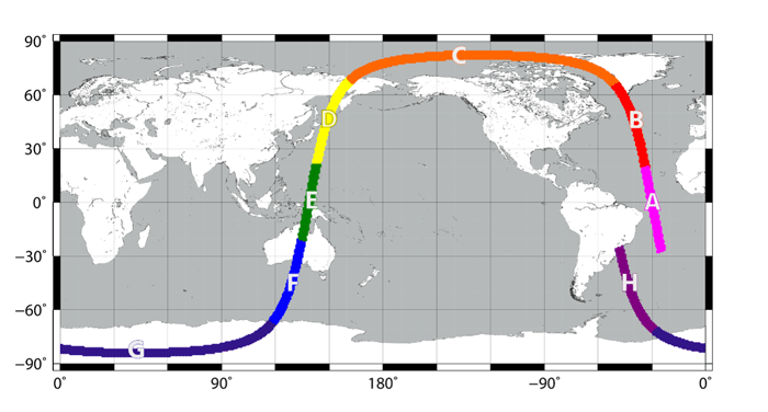
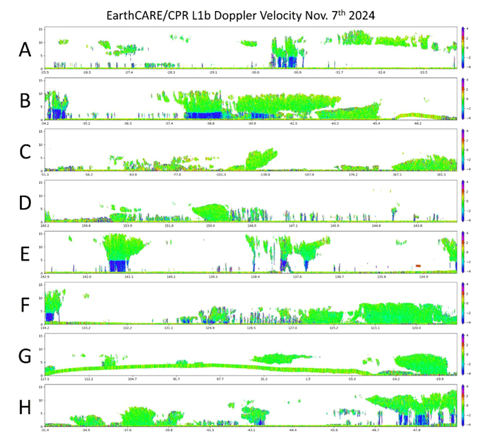
On January 14, 2025, we start releasing Level 1 Product, which contains engineering values converted from observation data of individual sensors, following the completion of the initial calibration & validation. (Appendix: Observation examples)
- CPR Data: Data on the vertical distribution and up and down motions of clouds
- ATLID Data: Data on the vertical distribution of clouds and aerosols
- MSI Data: Data on the horizontal distribution of clouds and aerosols
- BBR Data: Data on the radiative distribution of the Earth
Above data will be converted into Level 2 Product, which is the geophysical values (Cloud water content, Cloud ice content, Optical Thickness, etc.). In addition, data from multiple sensors of the EarthCARE satellite “Hakuryu” will be combined to provide accurate observation data that cannot be obtained from a single sensor alone. This data will be used to improve predictions of future climate change, contributing to studies on adaptation to climate change.
Level 2 Product will be released gradually from the middle of March 2025. (*3)
The data is available to anyone from the websites of JAXA and ESA:
- JAXA website (Japanese Version):
https://www.eorc.jaxa.jp/EARTHCARE/research_product/registration_j.html - JAXA website (English Version):
https://www.eorc.jaxa.jp/EARTHCARE/research_product/registration.html - ESA website (English Version):
https://earth.esa.int/eogateway/missions/earthcare
Future Prospects
The EarthCARE satellite "Hakuryu" will continue to acquire observation data throughout its operation. By analyzing acquired data, we will contribute to a better understanding of climate change and the improvement of its prediction accuracy. The data has been distributed only to special users, but with this release, the data will be available to all users, which is expected to increase the use of the data. We deeply appreciate the cooperation and support of stakeholders who assisted in the commissioning and initial calibration validation.
Role of Each Organization
- Japan Aerospace Exploration Agency (JAXA):
Development of CPR system, development and operation of data processing system and data dissemination system - National Institute of Information and Communications Technology (NICT):
CPR performance evaluation, CPR data processing algorithm development - European Space Agency (ESA):
Development of three sensors onboard the satellite, development and operation of satellite systems and data processing systems, and data dissemination system
Notes
*1 The CPR is the world's first spaceborne Doppler radar in W-band (94 GHz), jointly developed by JAXA and NICT.
*2 The name "Hakuryu", which means White Dragon, represents the distinctive external appearance of the EarthCARE satellite, which is white and has a solar array paddle that looks like a long tail. For further information on the nickname, please refer to:
https://www.satnavi.jaxa.jp/files/project/earthcare/earthcare_special/pickUptopics/topics_20240401_en.html
For detailed information on the overview of Earth Cloud Aerosol and Radiation Explorer (EarthCARE), please refer to:
https://www.satnavi.jaxa.jp/files/project/earthcare/earthcare_special/index_en.html
https://www.satnavi.jaxa.jp/files/document/pdf/EarthCARE_CPR_overview.pdf (Japanese Only)
*3 EarthCARE Products are broadly divided into Level 1 and Level 2.
Level 1: Engineering values converted from observation data acquired by sensors
Level 2: Geophysical values converted based on the engineering values of each sensor
For detailed information, please refer to:
https://www.eorc.jaxa.jp/EARTHCARE/data/prd_intro_e.html
Level 1: Engineering values converted from observation data acquired by sensors
Level 2: Geophysical values converted based on the engineering values of each sensor
For detailed information, please refer to:
https://www.eorc.jaxa.jp/EARTHCARE/data/prd_intro_e.html


 nict.go.jp