
First images from Cloud Profiling Radar (CPR) onboard Earth Cloud Aerosol and Radiation Explorer (EarthCARE) "Hakuryu"
- World's first measurement of vertical cloud motion from space -
June 27, 2024
The Japan Aerospace Exploration Agency (JAXA, President: Hiroshi Yamakawa) and the National Institute of Information and Communications Technology (NICT, President: Hideyuki Tokuda) have released the first images from the Cloud Profiling Radar (CPR) on board Earth Cloud Aerosol and Radiation Explorer (EarthCARE) (Japanese nickname: Hakuryu), which was jointly developed with the European Space Agency (ESA), and launched at 7:20 a.m. (JST) on May 29, 2024. The CPR is the world’s first spaceborne Doppler radar in the W-band (94 GHz) and was jointly developed by JAXA and NICT. The commissioning phase of the CPR is currently underway and the first observations were conducted on June 12 and 13. The CPR observed the cloud area in a stationary front, called the Baiu front, over the ocean at east of Japan, measured the internal structure of cloud, and succeeded in the world's first measurement of vertical cloud motion from space. The images below are a visualization of the measured data obtained by radar observation as a cloud cross section.

Three-dimensional diagram showing the vertical distribution of the radar reflectivity factor (left) and Doppler velocity (right) by the CPR. The horizontal distribution of clouds is calculated using data from the geostationary meteorological satellite, Himawari-9. Himawari-9 data was provided by the Japan Meteorological Agency. Image credit: JAXA/NICT/ESA.
You can see the video of the CPR first images here.
At around 13:36 on June 13, 2024 (Japan Standard Time), the CPR observed a cloud area in the Baiu front over the ocean at east of Japan. The CPR measured the cloud distribution reaching an altitude of approx. 13 km, and found the characteristic that the Doppler velocity increases downward at altitudes below approx. 5 km. This can be considered to indicate the high falling speed of the raindrops. Conventionally, these data can be obtained only by ground radar or airborne radar with limited observation areas, but the CPR onboard the EarthCARE satellite enables uniform observation of the entire earth.
It is expected that the CPR's observations of various cloud regions, including the Baiu front, will contribute to elucidating the mechanism by which cloud droplets grow into precipitation. In addition, the effect of clouds on the climate system is greatly influenced by factors such as cloud height, overlapping patterns, and cloud type. Therefore, using the CPR to measure vertical distributions of clouds, including their vertical motions on a global scale, will contribute to elucidating effects of clouds on the climate system.
JAXA and NICT will continue to conduct the commissioning phase of the CPR (for about six months) and then move to the mission operation phase. Data will be made available on the JAXA G-Portal and the European Space Agency (ESA) website. ESA is currently conducting the initial functional verification of the ESA’s three sensors on the EarthCARE satellite. We plan to announce the first images that combines the CPR and ESA sensors at a later date.
Role of each organization
- Japan Aerospace Exploration Agency (JAXA): Development of CPR system, development and operation of data processing system and data dissemination system.
- National Institute of Information and Communications Technology (NICT): CPR performance evaluation, CPR data processing algorithm development.
- European Space Agency (ESA): Development of three sensors onboard the satellite, development and operation of satellite systems and data processing systems, and data dissemination system.
Attachment
Overview
At around 13:36 on June 13, 2024 (Japan time), Cloud Profiling Radar (CPR) onboard Earth Cloud Aerosol and Radiation Explorer (EarthCARE) "Hakuryu" captured a cloud area in a stationary front, called the Baiu front, over the ocean at east of Japan.
Figure 1 shows the three-dimensional distributions of radar reflectivity factor and Doppler velocity (vertical cloud motion) measured by the CPR. Figure 4 shows the orbit of the EarthCARE satellite superimposed on a cloud image taken by the geostationary meteorological satellite, Himawari-9. Figure 2 shows the radar reflectivity factor of the CPR observation results between points A and B shown in Fig. 4, and Figure 3 shows the vertical cloud motion observed by Doppler measurements of the CPR.
The CPR captured cloud distribution reaching an altitude of approx. 13 km and, for the first time in the world, measured the vertical motion of clouds from space using Doppler radar measurements. Through the CPR observations, it was confirmed that the Doppler velocity increases downward at altitudes below approximately 5 km. This can be considered to indicate the high falling speed of the raindrops.
The cloud and precipitation process, in which cloud droplets grow into rain, plays an important role in numerical weather prediction models that predict heavy rainfall and climate models that project future climates. This is the world's first measurement of the vertical motion of clouds in a cloud region in the Baiu front from space. It is expected that future observations in various cloud regions will lead to a better understanding of the mechanism by which cloud droplets grow into rain and will improve the cloud and precipitation processes in numerical models, thereby improving the accuracy of predictions. In addition, the effect of clouds on the climate system is greatly influenced by factors such as cloud height, overlapping patterns, and cloud type. Therefore, using the CPR to measure vertical distributions of clouds, including their vertical motions on a global scale, will contribute to elucidating the mechanism by which clouds affect climate change.
Explanation of the observation image
Figures 1, 2, and 3 are observation images of the cloud area in the Baiu front over the ocean at east of Japan (near 35 degrees north latitude, 147 degrees east longitude) captured by the CPR at around 13:36 on June 13, 2024 (Japan time). The CPR is the world's first spaceborne Doppler radar in the W-band (94 GHz), and was jointly developed by JAXA and NICT. Figure 4 shows the orbit of the EarthCARE satellite along with cloud images from Himawari-9. The observation results of the CPR between points A and B shown in Figure 4 are shown in Figures 2 and 3.
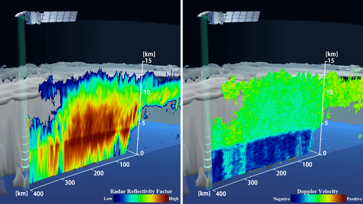
Figure 1: Three-dimensional diagram showing the vertical distribution of the radar reflectivity factor (left) and Doppler velocity (right) by the CPR. The horizontal distribution of clouds is calculated using data from the geostationary meteorological satellite, Himawari-9. Himawari-9 data was provided by the Japan Meteorological Agency. Image credit: JAXA/NICT/ESA.
Figure 1 (left) and Figure 2 show the vertical distribution of the "radar reflectivity factor," a value that indicates the degree to which radio waves emitted from a radar are scattered by cloud particles. The left side of Fig. 2 shows the cloud structure from the lower to upper levels reaching a width of approx. 300 km and an altitude of approx. 13 km, and from this cloud structure we can see that the upper clouds are spreading to the right side of Fig. 2.
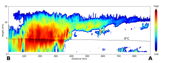
Figure 2: Vertical distribution of the radar reflectivity factor by the CPR. Image credit: JAXA/NICT/ESA.
Figure 1 (right) and Figure 3 show the Doppler velocity, which indicates the vertical cloud motion. In the figure, you can see that the Doppler velocity increases downward at altitudes below approx. 5 km.
In Figs. 2 and 3, the black dashed line shows the height of 0°C calculated from the initial value of the Japan Meteorological Agency's Meso-Scale Model GPV (Grid Point Value). Since rainfall occurs at heights below 0°C, the characteristic of the Doppler velocity increasing downward at heights below approx. 5 km altitude can be considered to indicate the fast fall velocity of raindrops.
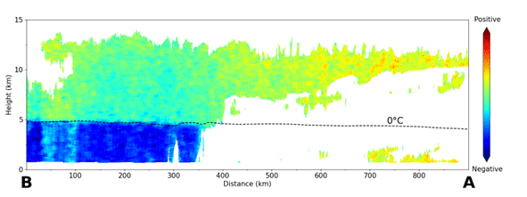
Figure 3: Vertical distribution of Doppler velocity by CPR. Image credit: JAXA/NICT/ESA.
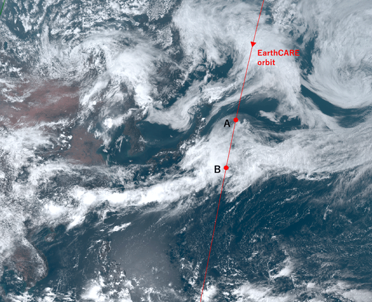
Figure 4: Cloud imagery from the Himawari-9 meteorological satellite with the orbit of the EarthCARE satellite overlaid. Image credit: JAXA/Japan Meteorological Agency.
Figure 4 shows the orbit of the EarthCARE satellite shown here, superimposed on a cloud image taken by the geostationary meteorological satellite, Himawari-9. The CPR observation results between points A and B shown in Fig. 4 were described in Figs. 2 and 3.
Since the CPR is currently undergoing the commissioning phase, the observed values have not been calibrated and therefore no numerical values have been entered into the images shown here. These values will be determined as we proceed with the calibration of the CPR.
By conducting research using such CPR observational data in collaboration with universities and research institutes, we aim to elucidate the mechanism by which clouds affect climate system and contribute to improving the accuracy of weather and climate models.
Supplement
Earth Cloud Aerosol and Radiation Explorer (EarthCARE) (Japanese nickname: Hakuryu)
The name "Hakuryu", which means White Dragon, represents the distinctive external appearance of the EarthCARE satellite, which is white and has a solar array paddle that looks like a long tail. For more information, please refer to:
https://www.satnavi.jaxa.jp/files/project/earthcare/earthcare_special/pickUptopics/topics_20240401_en.html
https://www.satnavi.jaxa.jp/files/project/earthcare/earthcare_special/pickUptopics/topics_20240401_en.html
Commissioning phase
Operation to confirm that observation sensors have the required functions and performance.
Doppler velocity
The velocity of an object, converted from the measured value of the frequency shift of the reflected wave (Doppler velocity measurement) due to the Doppler effect caused by the movement of the object (well-known for changing pitch as ambulances pass).
JAXA G-Portal
Media Contact
National Institute of Information and Communications Technology
Public Relations Department, Press Office
E-mail: publicity@nict.go.jp